Why this exists
Oklahoma's metros plan for tornadoes, floods, and heat with data scattered across a dozen federal portals. This atlas puts the region's hazard, vulnerability, and demographic record on one map, so a planner, an emergency manager, or a resident can answer a concrete question in minutes: where does water go, where have tornadoes actually tracked, who gets hottest, what have storms cost, and who has the least capacity to cope.
Click any census tract and the atlas returns one combined readout: social vulnerability, the demographic flags that matter in an emergency, and the tract's hazard exposure. That cross-layer view, not any single dataset, is the point.
What each layer is for
Flooding
Extreme heat
Severe weather
People and vulnerability
Loss and insurance
Property and market
Data sources and credits
Every layer comes from a federal public-domain source or an attribution-only open source, snapshotted into this atlas's own files. Nothing here hot-links a government server at view time.
The market layers (Zillow, Redfin) are free to use with attribution but are commercial market indicators, not public records. They support market analysis; they are not appraisals and not comparable sales.
| Dataset | Publisher | Used for | License / credit |
|---|---|---|---|
| National Flood Hazard Layer (snapshot) | FEMA | Flood zone layer, tract SFHA shares | U.S. Government work. Credit: FEMA. |
| Severe weather GIS: tornado tracks, 1950–2025 | NOAA Storm Prediction Center | Tornado track layer | U.S. Government work. Credit: NOAA SPC. |
| CMRA Screening Data (tract summaries) | Interagency (resilience.climate.gov / USGCRP) | Projected heat days, 2-inch rain days | U.S. Government work. Credit: CMRA. |
| Urban Heat Watch, Oklahoma City, August 12 2023 | NOAA NIHHIS + CAPA Strategies (2023 cohort) | Observed heat traverse points | Public campaign data. Credit: NIHHIS / CAPA Strategies. Oklahoma City is the metro with a campaign; the traverse covers the OKC core south into Cleveland County, and Tulsa has no campaign to date, so the layer is blank there. |
| National Risk Index (census tracts) | FEMA | Expected annual loss in dollars, by hazard | U.S. Government work. Credit: FEMA. Modelled screening estimates, not a property-level appraisal. |
| NFIP redacted claims | FEMA (OpenFEMA) | Flood insurance claims paid, by tract | U.S. Government work. Credit: FEMA. Claim locations are redacted to the tract; coordinates in the source are rounded too coarsely to map. |
| Severe weather GIS: hail and wind reports, 1955–2025 | NOAA Storm Prediction Center | Hail and damaging wind layers | U.S. Government work. Credit: NOAA SPC. Observer reports, so density reflects reporting as well as occurrence. |
| Earthquake catalogue | USGS | Earthquake epicentre layer | U.S. Government work. Credit: USGS. |
| Developmental house price index (census tracts) | FHFA | Five-year price change layer | U.S. Government work. Credit: FHFA. A repeat-sales index, not a valuation; thin-sales tracts are noisy. |
| ZHVI and ZORI, ZIP level | Zillow Research | Home value, rent and price-to-rent layer | Free for use with attribution. Credit: Zillow. A smoothed market index over the homes Zillow observes, not a complete sales record. |
| County market tracker | Redfin Data Center | Median sale price, days on market, supply | Free for use with attribution. Credit: Redfin. MLS-derived county aggregates — market analysis, not comparable sales. |
| Building Permits Survey | U.S. Census Bureau | Permitted units and construction value | Public domain. Credit: U.S. Census Bureau. |
| LEHD LODES 2023 | U.S. Census Bureau | Job density and employment centres | Public domain. Credit: U.S. Census Bureau. Covers jobs under state unemployment insurance, so most self-employment is absent. |
| Storm Events Database, 1950–2026 | NOAA NCEI | Event points, damage choropleth, loss model | U.S. Government work. Credit: NOAA NCEI. |
| Social Vulnerability Index 2022 | CDC / ATSDR | SVI layer, readout, equity weighting | Public domain. Credit: CDC/ATSDR. |
| TIGER/Line cartographic boundaries 2024 | U.S. Census Bureau | Tracts, county, place outlines | Public domain. Credit: U.S. Census Bureau. |
| ACS 5-year estimates 2018–2022 | U.S. Census Bureau | Demographic layer, exposure model | Public domain. Credit: U.S. Census Bureau. |
| NLCD 2021 impervious surface | USGS / MRLC | Impervious layer | Public domain. Credit: USGS/MRLC. |
| GlobalMLBuildingFootprints (2026-07-24 release) | Microsoft (Bing Maps) | Building footprints layer, 2D and 3D views, ML height estimates | CDLA Permissive 2.0. Credit: Microsoft GlobalMLBuildingFootprints. Heights are model estimates from imagery, not survey data. |
| Protomaps basemap (build 2026-07-29) | Protomaps, from OpenStreetMap | Basemap ("Streets") | Open style; data ODbL. © OpenStreetMap contributors. |
| World Imagery tile service (view-time) | Esri | Optional "Satellite" basemap | Tiles © Esri — Source: Esri, Maxar, Earthstar Geographics, and the GIS User Community. Streamed at view time, not snapshotted; the only layer that needs the network. |
| CPI-U (CPIAUCSL) | U.S. BLS via FRED | Inflation adjustment of storm damages | Public data. Credit: BLS / FRED. |
Excluded by license: First Street / Risk Factor (proprietary), Esri-hosted basemap data beyond the optional view-time satellite tiles, and Google Maps data.
Methodology & assumptions (mitigation analytics)
The analytics panel and the companion workbook (analytics/loss_model.xlsx) price mitigation with public, citable methods. Every number they show is illustrative, built for ranking places and hazards, not for appraising a specific project.
- Annualized loss. NCEI Storm Events damages (property plus crops), each year converted to current dollars with annual-average CPI-U (FRED CPIAUCSL), divided by the 77-year record.
- Discount rate: 7%. The OMB Circular A-94 (1992) rate, which FEMA reinstated for Hazard Mitigation Assistance benefit-cost analysis effective April 8, 2025. The workbook exposes it as an input.
- Project life: 30 years, a common FEMA BCA default for building projects. Also an input.
- Benefit-cost ratios. NIBS, Natural Hazard Mitigation Saves (2019 report, Table 1, federal-grants row): riverine flood 7:1, wind 5:1, earthquake 3:1, wildland-urban fire 3:1, 6:1 across all hazards. The 2019 study remains the institute's latest full report as of this build (July 2026). No headline ratio is hardcoded from memory; the workbook reads these values from a labeled table with the citation attached.
- Exposure. Property exposure multiplies each tract's housing units by its median home value by its share inside the special flood hazard area. Vulnerable population counts residents of tracts at or above the 75th SVI percentile that also touch the SFHA or fall in the top quartile of projected heat days.
Storm Events undercounts small losses and geocodes damage to the reporting jurisdiction, so treat jurisdiction totals as floors. Commission a project-level FEMA BCA before committing funds.
Geographic scope
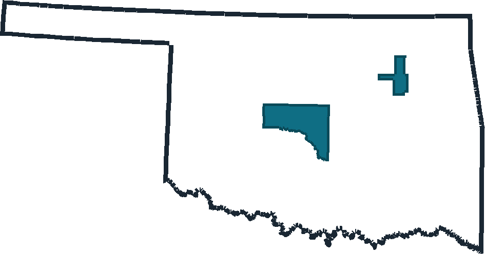
The atlas covers four Oklahoma counties: Oklahoma, Cleveland, and Canadian in the Oklahoma City metro, plus Tulsa County. That takes in Oklahoma City, Norman, Moore, Edmond, Midwest City, Yukon, Mustang, El Reno, Tulsa, Broken Arrow, Jenks, and Owasso, along with the smaller incorporated cities and towns inside those counties. The footprint is deliberately non-contiguous — the OKC metro and Tulsa sit about 90 miles apart — so the map opens zoomed out far enough to show both, and the gap between them holds no data. Oklahoma City's limits reach slightly into Pottawatomie County; that sliver falls outside the county footprint and is clipped off. The pipeline clips to a single list of FIPS codes in config.py; edit that list and re-run to cover more of Oklahoma.
Basemap data © OpenStreetMap contributors.